Satellite map of an urban area in Kyiv, Ukraine, showing abandoned plots of land with walls on Yaroslavska Street and nearby streets, overlaid with map markers indicating locations of shops, restaurants, and other points of interest.

Abandoned Kyiv

Using Google MyMaps to map abandoned land and negelcted buildings in Kyiv, with crowdsourcing.

LINK TO THE MAP / ПОСИЛАННЯ НА КАРТУ

Покинутий Київ

Це не просто карта. Це заклик до дії.
Ми використовуємо Google MyMaps, щоб разом позначити покинуті ділянки та занедбані будівлі у Києві.
Кожен маркер — це можливість змін. Долучайся, додавай, поширюй.

Як додати на карту / How to Add to the Map

  • Screenshot of a map editing interface over a satellite view of Kontrakova Square, displaying icons for adding lines, driving routes, cycling routes, and walking routes, with landmarks like Samson and the Lion, GRKY Espresso Bar, and clothing shops visible.

    Знайдіть місцезнаходження Виберіть інструмент «Полігон» – Додати лінію або фігуру

    Find the Location. Then Choose the Polygon Tool - Add Line or Shape

  • Satellite map of Kontraktova Square showing roads, trees, buildings, and landmarks including a clothing shop, a gift shop, and a statue named Samson and the Lion.

    Окресліть будівлю або земельну ділянку. Додайте назву або адресу та будь-яку іншу інформацію про місце.

    Outline the building or land. Add the name or address and any other relevant information.

  • Satellite view of a city square called Kontraktova Square with a highlighted area labeled "ostunnyyy Dvir," featuring a sanded building and several trees, nearby bus stops, a clothing shop, and a monument Petra.

    Виберіть значок відра з фарбою, додайте прозорість, виберіть червоний колір.

    Choose the paint bucket, add transparency, select a red colour.

  • Satellite view of a university campus with a large Ferris wheel, surrounding buildings, and a highlighted roofed structure labeled 'Гостинний двір'.

    Виберіть значок камери. Додайте фотографію, якщо вона у вас є.

    Select the camera icon. Add a photo if you have one.

  • A satellite map view of a section of Kiev, Ukraine, showing the National University of Kyiv-Mohyla Academy, Hostynny Dvir building, KMA Gift Shop, and surrounding trees and structures. Labels identify locations and streets, and there is a large Ferris wheel at the bottom right.

    Потім виберіть значок шпильки на карті та додайте його поверх місця розташування. Додайте назву/адресу/інформацію.

    Then select the map pin icon and add on top of the location. Add name/address/information.

  • Satellite map indicating a rotting building on Shchekavytska Street, covering 0.055 hectares with an area of 107 meters.

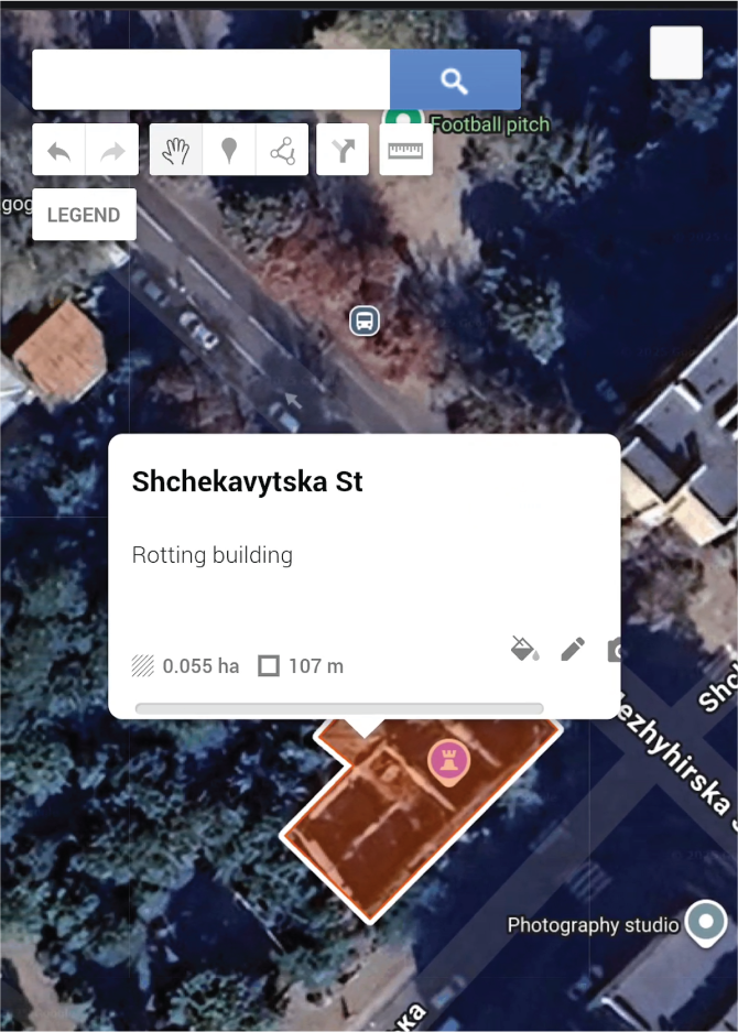
    Це має виглядати ось так, коли ви закінчите та натиснете на нього.

    It should look like this when you are finished and you click on it.